Tu-tump, tu-tump, tu-tump…
Da qualunque lato mi giri, continuo a sentire questo rumore assordante nelle orecchie.
Paradossale: non è il russare dei miei compagni di camerata in rifugio che mi tiene sveglia, ma il battito del mio cuore.
Un suono a cui siamo abituati, ma che ai 3.498m del Rifugio Mantova, percepibilmente accelerato dall’altitudine, diventa un rumore che rimbomba nelle orecchie.
Quello, e il pensiero di ciò che dovremo fare tra poche ore: alle 4 meno dieci suonerà la sveglia e ci prepareremo per uscire nel buio della notte e iniziare la scalata verso Capanna Margherita.
Il mio cuore già batte troppo veloce così, sdraiata a letto: cosa farà lassù allora?
Non sono la sola a sentirsi strana: nella camerata silenziosa si sentono costantemente i movimenti dei miei compagni di viaggio. Chi per il mal di testa, chi per la semplice eccitazione, quasi nessuno di noi riesce a dormire più di qualche ora.
Durante l’ennesima tappa al bagno, mentre risalgo le scale che portano alla camerata e sento l’affanno afferrarmi i polmoni per questo gesto semplice ma improvvisamente complesso, mi chiedo se tutto questo non sia una follia.
Ricominciare a camminare
Fino a qualche mese fa, l’idea di ricominciare questo progetto era solo un bel sogno. Dopo lo stop del Covid a M4810c’era stata qualche occasionale battuta, ma non avevo più realmente pensato che sarei arrivata a scalare le cime più alte d’Italia narrando le gesta di questo gruppo di consulenti milanesi evolutosi in alpinisti.
E poi una telefonata: M4810 riparte, ci sarai?
Non si può dire di no a certe proposte.
Ma tra il dire e il fare c’è di mezzo la preparazione, e questo finale (che per qualcuno è un inizio) è ricco di sfide in tal senso, perché non c’è stato il tempo né la possibilità di strutturare un percorso completo come due anni fa.
Non solo: tante condizioni non sono ideali, come il caldo fuori norma che questo giugno ha portato e l’assenza di pioggia, che minacciano il ghiaccio su cui dovremo camminare. Ma ormai lo sappiamo, il Covid ce l’ha insegnato: le condizioni ideali non esistono.
E così abbiamo iniziato il nostro trekking da Punta Indren, 3.275m raggiunti con una corsa in funivia che non aiuta l’acclimatamento.
Attraversiamo un primo tratto di ghiacciaio che di ghiaccio ha ormai ben poco: è quasi completamente coperto da detriti. Si chiama “ghiacciaio nero”, ci dicono le guide, e la sua espansione nelle nostre Alpi è uno dei tanti segni tangibili del riscaldamento globale che stiamo vivendo, oltre a diventarne una concausa perché le rocce scure contribuiscono a scaldare il ghiaccio e accelerarne lo scioglimento.
Serve Kalipè
Il tratto che ci aspetta oggi è limitato, il rifugio Città di Mantova si trova a circa 3.500 metri, ma è già un’altitudine di tutto rispetto: camminare quassù comporta più fatica, richiede più calma, più lentezza.
Kalipè, come dicono le guide.
Kalipè è un augurio (e un invito) proveniente dalle zone himalayane, dove di altitudine sono esperti: significa più o meno “camminare sempre a passo corto e lento”.
Il nostro Arnaud, il responsabile del gruppo di guide alpine di Courmayeur che ci accompagna in queste imprese da ormai 4 anni, lo chiama più semplicemente “passo della guida”.
Prova a spiegarcelo nuovamente dopo la cena in rifugio, durante il briefing in cui ci racconta gli ultimi dettagli dell’ascesa che ci aspetta: è un modo di camminare essenziale in montagna, ritmato, costante, senza strappi. Un passo che ha come una piccola pausa tra l’uno e il successivo. È il ritmo che ci porterà in cima al Rosa, ci promettono - e anche oltre, se lo sapremo seguire.
Annuiamo, seppur visibilmente poco convinti. Siamo silenziosi, ma vedo riflessi negli occhi dei miei compagni le stesse paure che affliggono me: di non farcela, di stare male, di essere d’intralcio, di sbagliare…
Ma nessuno dice nulla, quindi andiamo a dormire. Se di dormire si può parlare, poi.
Quando al “mattino”, ovvero alle 4 di notte, ci troviamo a fare colazione, non c’è quasi nessuno che non stia accusando i colpi della nottata, e chi manca manifesterà qualcosa a fine giornata: mal di testa, stanchezza, problemi di stomaco, affanno,…
Sarà una lunga giornata, ma questo già lo sapevamo. A ben vedere, forse è proprio per questo che lo facciamo.
È in questa sfida oltre i limiti del proprio corpo e della propria mente, così lontano dalla nostra zona di comfort, che si gioca la partita. È qui che avviene il cambiamento.
Alba a quattromila metri
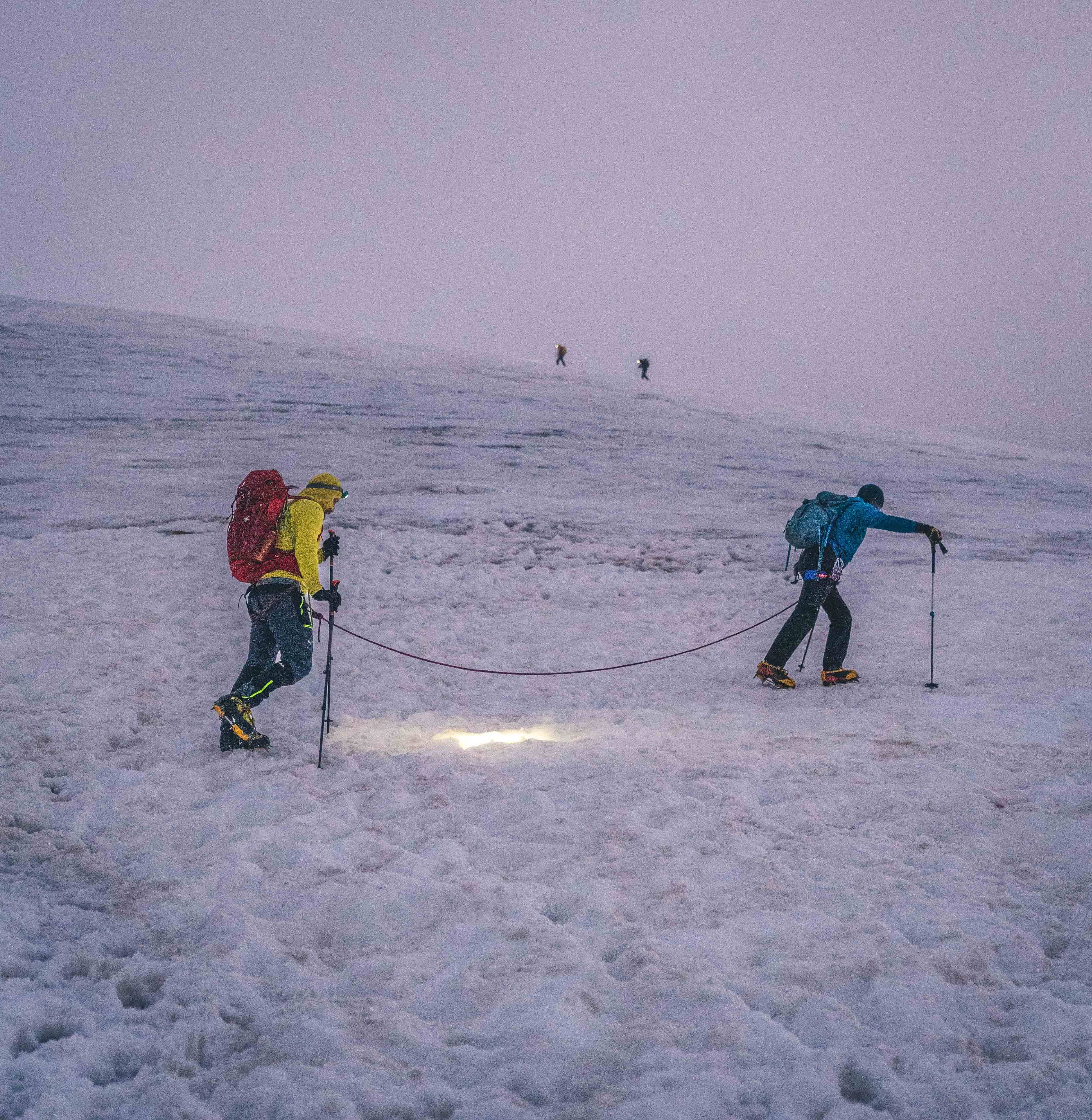
Usciamo accolti da un’aurora silenziosa e limpida, in una notte parecchio più calda di quello che ci aspettavamo. Sembra una buona notizia, ma in verità forse non lo è: il clima caldo è ciò che sta rendendo sempre più problematiche le uscite alpinistiche, e le guide notano subito che la visibilità è buona ma il cielo è coperto di nuvole che si muovono veloci…in quota potremmo trovare vento e nebbia.
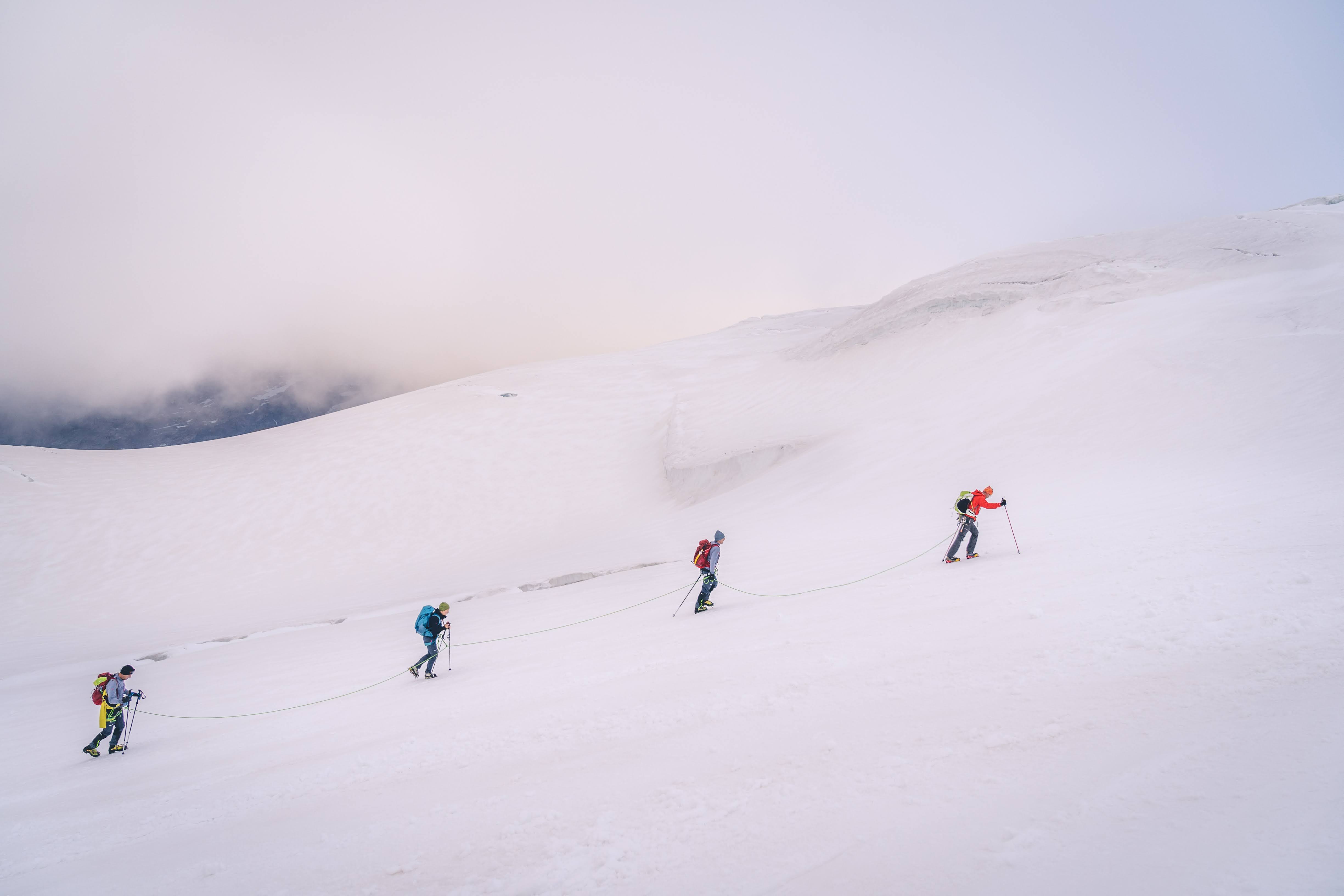
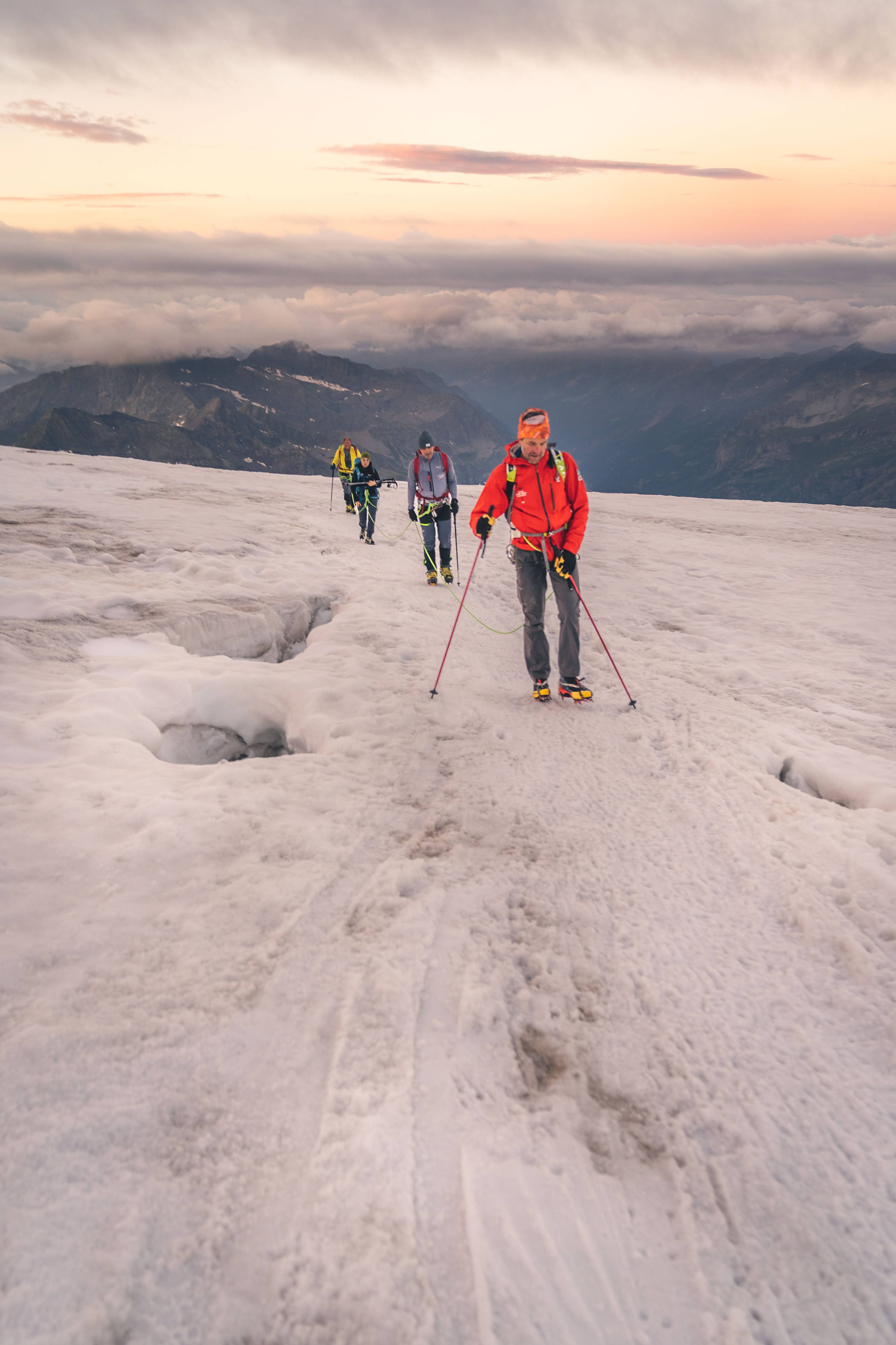
Ci dividiamo in cordate e, ramponi ai piedi, iniziamo a camminare: sollevo-appoggio-pausa, sollevo-appoggio-pausa, sollevo-appoggio-pausa.
Guardo il passo della guida davanti a me e mi sforzo di seguirlo. Mi sembra strano, forzato, ma se lo usano loro significa che funziona no?
Sollevo-appoggio-pausa, sollevo-appoggio-pausa…
Sento che il cuore rimane stranamente regolare, mentre stanotte solo fare le scale per il bagno mi mandava i battiti a mille.
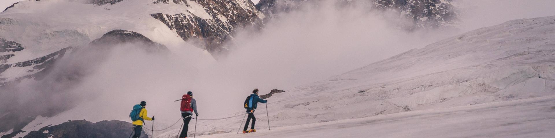
Mi sembra che procediamo lenti, estenuantemente lenti. Altre cordate ci superano con ritmo più sostenuto, mentre ci avviciniamo ai primi inquietanti crepacci diretti al Colle del Lys.
Ferite azzurre nel bianco della neve, buchi tanto affascinanti quanto spaventosi che si aprono per chissà quanti metri sotto di noi…ci buttiamo uno sguardo veloce mentre li superiamo il più rapidamente possibile, passando sui famosi “ponti di neve” che compongono la traccia.
Sollevo-appoggio-pausa, sollevo-appoggio-pausa…
La salita si fa più sostenuta, ma il battito del cuore incredibilmente rimane costante. Sorrido, pensando che forse sono stata troppo dubbiosa, che forse possiamo davvero farcela tutti quanti.
Sorrido…ma poi il sorriso mi si gela sulle labbra.
Valichiamo un colle e improvvisamente ci investe un vento freddo e una nebbia spessa che fa sparire alla vista la cordata davanti a noi: il maltempo che le guide temevano ci ha raggiunti, o meglio noi abbiamo raggiunto lui.