The preparation
Legs
Warm-up and cool-down
We all know it: warm-up and cool-down are very important for maximising exercise and avoiding injuries. Unfortunately - sometimes because we’re lazy and other times because we’re tired - we forget about them…
and we can’t afford to do so! Because, to tell the truth, these important activities don’t take us more than 20 minutes in total before and after the trip.
BEFORE STARTING THE HIKE
Usually we start our hikes with at least a 2-hour trip in the car or the bus after having had to wake up at sunrise – which few enjoy. So, we arrive at the starting point sleepy, a bit stiff, and shivering in the cool morning air. We can definitely help our muscles to wake up by starting at a slow pace. This, however, isn’t possible on all trails. So, it’s a good idea to take 5/10 minutes to stretch! It’s important to avoid putting excessive strain on our muscles in this phase as they’re still cold!
- Loosen your ankles turning the foot in clockwise and counterclockwise direction and warm up your calves by doing small lifts onto your toes
- Knees: slightly bend your legs, rest your hands on your knees, and rotate from the inside towards the outside and vice versa
- Quadriceps: stand next to something you can use to support yourself with one hand; lift a leg, holding the ankle with the other hand, and bending it until you feel some tension in your muscle
- Back: do simple circles with your arms
- Neck: slowly and gently, bend your head and make circles following the natural bend of your neck
AT THE END OF THE HIKE
We’re approaching the end of the journey, many are tired and in pain, and we can’t wait to get back to the cars and go home… so we pick up the pace and once we reach the end point we sit on the ground and, if someone really insists, maybe we do some stretching. This is the worst thing we can do! It means suddenly halting the movement: our muscles, still warm, remain contracted and our joints remain compressed. For this reason, we have to cool down – to follow a slow transition back to resting state. This means starting to slow down during the last 10/15 minutes of the descent, trying to maintain a loose and relaxed pace. Once arrived at the destination, it’s a good idea to do some stretching exercises.
The fundamental exercises regard the big muscle groups. Each position should be held for around 20 seconds:
- Back muscles (ex. hang from a bar or work in couples)
- Quadriceps (stretch as described in warmup)
- Hamstrings (ex. standing up, cross your legs, keeping your feet parallel. Bend forward slightly, exhale and try to touch your toes)
- Calves (ex. bend a leg forward, like in a lunge, resting with an arm against a wall or tree. You should feel your back calf stretching)
You can also work on your other muscle groups, but remember to also relax your joints: ankles, knees, and shoulders, avoiding sudden movements.
The best way to understand which exercises you need the most is to listen to your body!
The first steps
The M4810 team is still just at the beginning of its training journey, and there is still a lot of debate around what this challenge really entails in terms of preparation.
Our work often brings us far from home and forces us to break our routine and reschedule our daily activities. This doesn’t make organising training easy.
For now, we’ve set some basic rules and indications that we plan to then turn into a real plan with the help of some experts.
Be aware: one weekly workout in the gym won’t be enough. We keep saying it in order to make it real. The more we move forward with the project, the more we need to increase the frequency and intensity of our training. A training journal for keeping track of dates, durations, and exercises may be useful in helping us be consistent.
Start gradually: it’s important, above all for those who don’t train or train very little, to be realistic and not overdo it. Starting with a 1 hour run or with exhausting exercises isn’t the right approach to athletic preparation
Mountains, mountains, mountains: when possible, the best training is hiking, which allows us to face elevation gain and different types of terrain
Always respect recovery time: we need to allow our bodies to rest as much as they need to, especially after a hike or a particularly long or difficult training session
Stomach
The right food for the right pace
Good preparation for an excursion requires us to also pay attention to nutrition. We start from the fact that we need energy, but without gaining weight
To start the right way, we should prepare our dinner the night before: carbohydrates are a must - as they make up a good energy reserve - as are vegetables and fruits, for their sugars. It’s also important to drink liquids in order to improve hydration levels. We should, on the other hand, avoid proteins, which are less important than carbohydrates and sugar for the effort that we must make.
BREAKFAST
It should be rich, balanced, and abundant: so, it would be best to have it with some time before the start of the hike. Either a sweet or a savoury breakfast is good. For a sweet one, you may want to have toast with honey, jam, or even butter, biscuits, fruit pie, cereal, fresh fruit, or yogurt. For a savoury one: ham, cheese, eggs. To drink, go for milk, juice, water, or tea.
SNACKS
During the hike, there are two key elements: hydration and simple sugars.
We have to constantly integrate liquids in order to avoid the excessive loss of mineral salts in our sweat and breath (vapour). So, it’s very important to drink water, even with added mineral salts.
Next, simple sugars reinforce our energy levels quickly since they are easy to digest. Fresh fruit (ex. apples) is always a good idea, but it’s heavy and bulky: dry fruit is better from this point of view. Energy bars are also great, but keep an eye on the ingredients: the less the better! Avoid energy bars that contain glucose/fructose syrup, vegetable oils, and additives.
PACKED LUNCH
We should prioritise food with a medium-high glycemic index. The classic sandwich works as long as it contains ingredients that are easy to digest. Choose well risen bread, ham or cold cuts that are low in fat, and a little cheese. Eggs also work. It’s best to avoid coffee (that may, due to its diuretic effect, contribute to liquid loss)… but we can allow ourselves a bit of dark chocolate!
DINNER
After a day of physical effort, we have to recover energy and the mineral salts that we lost.
A great idea is a soup with pasta or rice, rich in vegetable and legumes (ex. chick peas, beans, peas). If we want animal proteins, the best choice is fish. We can also add a portion of fruit that, together with vegetables, helps recover some vitamin content.
We'll start with the basics
We asked a doctor to give us some advice on complementing our training with the right diet.
We’ll start with what’s certain: for those who engage in athletic activities, energy consumption increases in the rest phase. For this reason, they need more calories. These calories should provide the right share of nutrients:
- Carbohydrates: 40% pasta, bread, and sugar to provide energy
- Proteins, amino acids: 15% meat, fish, eggs, legumes
- Fats: 25% milk, butter, oil
These nutrients should be consumed at various points throughout the day, ideally in 3 main meals and 2 snacks, concentrating the greater share of calories (particularly those under the form of carbohydrates) during the first part of the day.
Hydrating correctly is also very important, especially during a hike. Body water is indispensable in all physiological processes and biochemical reactions that happen within our body. Maintaining the right water balance (the rapport between water “entering” and “exiting” our body) is therefore fundamental for good health in the short, medium, and long term.
For now, these are the general indications, but soon we will each have personalised nutrition plans.
Heart
Put to the test!
Our expedition is teaching us that we need to learn to be a “group” in different and unexpected ways
We are a group. In business, of course, and this is our strength: being a team of complementary figures, that compensate for each other and that walk together towards a common objective with strong commitment.
We’re also a group when we’re in the mountains. But here, things - more or less unexpectedly, depending on our experience with hiking - aren’t so simple.
We left together, knowing that the goal that awaits us in 2020 is extremely ambitious. But, as soon as we started walking, we realised that our staying together, our being a group, would be understood and calibrated.
Being a group that walks in the mountains means acknowledging that each person faces the journey and their own difficulties in different ways and at different paces. It means accepting that it won’t be one big group, but smaller groups with different characteristics. This depends on the different levels of training and preparation, on which each of us can act, of course. It puts us face to face with a fundamental point, however: we must learn to know our rhythms and paces. In the mountains we can’t face a journey without being aware that, for safety reasons, it must be completed within a certain number of hours.
This division into smaller groups and the fact that not everyone always reaches the top has created a bit of a crisis among us… is this normal? Are there winners and losers? Have we already decided that some will reach the peak and many others won’t?
The answer is that it’s right to live this experience according to our own abilities and that our only fight is against our own limits… one colleague summarised this concept: “let’s let everyone decide where their own peak is”.
All this fit perfectly into the concept that we chose: not a race, but an expedition. And in an expedition, each person can find their place, contributing in different ways that are valuable in reaching the objective.
Here we come full circle to our being a cohesive team that doesn’t leave anyone behind and that gives everyone the opportunity to experience this adventure. We believe that being a “group” in this way can teach us a lot, even, and above all, to bring forward our business in a sustainable and valuable way.
When it's time to come down, something in us has changed
Our trip to Mont Fallère represented an important divide: it made us understand the difference between a hike and a more “serious” excursion
This is where we become truly aware of the dangers that our expedition can pose. What we bring home is the ability of the mountains to change us, to give us pieces of ourselves that we thought we lost or that we didn’t think that we had. We found these complex emotions at the Fallère hut, which hosted us and refreshed us: at its entrance we read something that seemed like it could have been written by us:
“You housed us, put as back in order mentally, fed us, weaned us onto nature…now relax and know for sure that we will come back.
We will come back in many, and new travellers will also come, because no one can be indifferent to the ample breath of the Fallère, where we are kids again, where we gladly go back to the origins. Where we stop the vice that is having, rejecting, and grasping everything.
When the moment comes to descend, back DOWN, something in us has changed, new possibilities have opened, we are able to better resist the tram-tram, we face the frum-frum. In the furious traffic, in the crowded hospital wards, in the shopping centres, and in the waits at tax offices I close my eyes for an instant, I see the Fallère and I feel the will, the instinct, the taste, and I know where I’m going. It’s the Fallère that comes to meet me. You can trust, and you can entrust! We will come back!!”
Baba Scala
Head
How do we pack?
There is no such thing as a definitive, universal checklist when packing a backpack! We’ll share the rules that we go by in packing a “standard” M4810 backpack for a day of summer hiking without particular technical difficulties
Let’s start with a simple and fundamental premise: packing a backpack (and the choice of it!) depends on:
- the season
- the duration of the trip
- the altitude to be reached
- the weather
- the type of trail
The M4810 follows the following three fundamental rules:
- bring only what’s essential
- pack everything the night before
- adjust your backpack well (shoulders, hips, closures, etc.)
Beyond these three fundamental rules, there are some other useful suggestions:
- place the lightest clothes or those that you don’t need immediately in the bottom of the backpack (ex. windbreaker, down jacket, thermal wear, etc.)
- the heaviest weight should stay as close to your body as possible: put the heaviest objects closest to your back (ex. water and food reserves, equipment)
- a note on your water bottle: while the best position is closest to your back, it’s also true that it’s a frequently used object. It can be placed close to the top of the backpack or in the designated side pockets if the backpack has them (avoiding, however, an excessive weight imbalance)
- put your frequently used clothes (ex. fleece) and medium weight objects (ex. first aid kit) in the centre of the backpack, towards the exterior and the top
- when distributing things, do so in a way that maintains an even weight distribution, not too much to the left or the right
- in the top, place the smallest and most frequently used objects (ex. map, call phone, sun glasses)
- it’s best to avoid hanging things from the outside of the backpack, if not specific equipment. The more hanging objects there are, the higher the chance that they get stuck to branches or rocks
- always bring at least one waterproof bag to keep your things in case of bad weather and to collect your waste to bring back down
The final issue: weight. How heavy should a backpack be? Even for this, we can go back to the initial premise… but we can say that a well packed backpack shouldn’t go beyond 4-5kg for a single day hike and 9-10kg for a multiple day hike with nights spent in a hut.
How do we evaluate a trip?
Before packing our backpacks, we always evaluate whether we can safely face the journey or not based on our competences and physical preparation
There are four fundamental elements to take into consideration:
Time: each trip is chosen based on the hours of light available; between summer and winter there’s a big different in the number of hours of light. This is considered in the planning: finding yourself in the dark in unknown areas, maybe without the proper equipment, raises your exposure to risks. Another element is that of individual times: each person has a different rhythm, based on their training level and preparation.
Elevation gain: the positive difference in altitude between the starting point and the arriving point; the other way around, the level difference is negative. The average level that a hiker can gain is around 400 metres in an hour; for the descent, the time is reduced by 1/3.
Terrain difficulty: there is a scale that indicates path difficulty. Looking just at hiking, therefore not considering climbing, the scale identifies the following types of hikes:
- T Tourist trail: trails for accessible to all, Routes on roads, mule tracks, or wide trails
- E hiking trail: trails that take place on all kinds of paths, or on obvious traces of passage through varied terrain (pasture, debris or screes)
- EE trail for experienced hikers: trails that are generally indicated by signs, but imply an ability to move well on arduous terrain, with slight technical difficulties and rocky sections
- EEA trail for experienced hikers with equipment: equipped route or via ferrata that lead the hiker on rocky walls or on crests and ledges, equipped with cables and/or steps
- EAI trail in snowy conditions: trails in snowy environments that require the use of snow shoes
Stages, Logistical support / Supply points: it’s always important to be familiar with the area in which the excursion will take place and know all the possible support points that may be useful in case of need or emergency (es. camps, huts, …)
There are the elements, together with the check of personal physical condition, that may be looked at in advanced of the first day of the trip.
The journey
M
3061
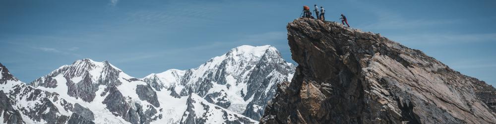
Mont Fallère

It is the first peak over 3.000m of our project
Mont Fallère is found in the Grand Combin Alps in the Aosta Valley.
Found between the Gran San Bernardo Valley and the Valdigne, it’s a great introduction to the magical world of the 3000s. Mont Fallère, situated in the heart of the Aosta valley, proposes a 360° panorama of all the Aosta valley peaks. Its layout is not the be underestimated, but overall it doesn’t present great difficulties, even if we need to be really careful in the final part of the ridge.
We go up in two stages: the first day up to the Fallère Hut; the second day we arrive at the summit and then we go down to the valley.
Read the story :)
M
3128
Pointe Lechaud
Our first alpinistic climb to a summit
Pointe Léchaud (3.128m) is located along the borderline between Italy (Valle d'Aosta) and France (Savoy).
It is located south of the Col de la Seigne (2.512m) between the Veny Valley and the Savoy Valley of the Glaciers.
We climb in two stages: on the first day we walk from La Visaille to the Elisabetta Soldini Hut (2.195m); on the second day up to the top and back to La Visaille.
From the hut we go up to the Col Chavannes (2.603m); from the hill we have to leave the marked path that begins to descend into the Chavannes valley, following a path on the right that crosses the very steep eastern slope of Mount Lechaud. The trail continues on the right, again not far from the crest of Mount Lechaud and crosses a small valley of stones or snow, reaching the wide basin where the Chavannes Glacier is located. Once we have put on crampons, we set foot on the glacier going diagonally to the left. From this point we gradually turn to the right pointing directly to the top, which can be reached by overcoming some easy rocky steps. What we see is a vast and spectacular panorama on the Italian side of Mont Blanc.
M
3842
Vallée Blanche

Crossing the Gigante glacier towards the Aiguille du Midi
Although it may seems like a "scenic walk", the Vallée Blanche should not be underestimated, as it is an itinerary that involves crossing the Gigante glacier. It is always necessary to be accompanied by an Alpine Guide who knows the itinerary very well and knows how to avoid the dangers.
We go up by cable car to Punta Helbronner (3.462m), we wear harnesses and crampons and we tie ourselves together.
The first section makes us lose altitude and then we start to climb towards the Aiguille du Midi. The last section includes the ascent of the snow-covered ridge of the Aiguille du Midi, reaching 3.842m.
The return is with the panoramic cable car which takes us back to Punta Helbronner.
M
4559
Monte Rosa

2 full-immersion days of technical alpine skill training on Monte Rosa
The Monte Rosa is a mountain range that is found in the Pennine Alps, along the watershed line between Italy (on the border of the Aosta valley and Piedmont) and Switzerland. It gives name to the Monte Rosa Alps supergroup, which in turn is composed of various important groups and subgroups, east of the Cervino and south-east of the Mischabel range. It is the most extended range in the Alps, and second in height after the Mont Blanc. It is the highest mountain in Switzerland and the second in Italy, and has the highest average height, containing 9 of the 20 highest peaks of the chain.
M
4061
Gran Paradiso

The Gran Paradiso is the only mountain over 4000m that is fully on Italian territory
The Gran Paradiso is the only mountain over 4000m that is fully on Italian territory. A classic and fascinating climb: after a first part on ice, to be able to reach the peak marked by a statue of the Virgin Mary, you must pass some simple rocky crossings.
M
4810
Monte Bianco

Mont Blanc (Monte Bianco in Italian) is a mountain situated in the North-occidental Alps, in the Graian Alp range, on the watershed line between the Aosta valley (val Veny and val Ferret in Italy), and Haute-Savoie (the Arve valley in France), in the territories of Courmayeur and Chamonix, which give name to the Mont Blanc Massif, belonging to the subsection of the Mont Blanc Alps.
It’s 4808,72m (the last official measure was taken September 13, 2017) make it the highest mountain in the Alps, in Italy, in France, and in general in Europe if we exclude the Caucuses. This is why it’s called the King of the Alps. It shared a spot on the list of the highest Seven Summits with Mount Elbrus in the Caucuses.
Primarily granite full of peaks and crests, cut by deep glacial valleys, it is internationally renowned for its climbing and, from a historical point of view, the birth of mountaineering coincides with its first ascent: August 8, 1786.